Laos features a diversity of landscapes and ecosystems. The country is landlocked and heavily forested, with 80% of land cover featuring hilly or mountainous terrain, and the remaining 20% comprising plateaus and lowland valleys along the Mekong floodplain.
Land and mineral resources
Forest (including primary and potential forests) covers the majority of land area in the country (>80%). 10% of total land is used for agriculture, while arable soil for cultivation is responsible for less than 7% of total area.1
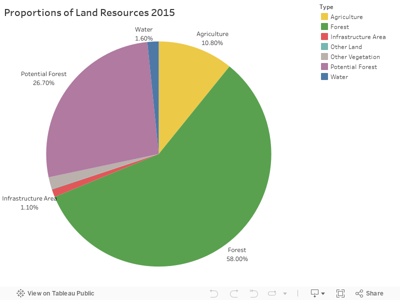
Created by: Open Development Laos. Source: Lao Ministry of Natural Resources and Environment. 2020. “National Report on Land Degradation Neutrality Target Setting Programme: Lao PDR.”
Laos has rugged mountainous terrain with rich mineral resources. Crucial minerals previously exploited include copper, gold, iron and silver, while other minerals for commodities are coal, gypsum, lead, potash, sapphire, tin and zinc.2 The mining and quarrying industry is important to the development of infrastructure and the economy by providing resources and generating revenues from investments, contributing roughly 10,500 billion kip to the total GDP in 2017, a 7% increase from 2013.3
Forest resources
As of 2015, Laos has approximately 13.2 million hectares of forest area. Mixed deciduous forest is the most dominant, accounting for about 9.4 million hectares. The other types of forest include dry dipterocarp, dry evergreen, coniferous and mixed coniferous and broadleaved forest. Besides these, there are also unstocked forest of regenerating vegetation and bamboos (27.30% of total area).4 Forest resources are crucial to economic development and livelihoods in Laos. The forestry rents contributed 3.8% to GDP in 2016.5 Forest also provides invaluable non-timber forest products (NTFPs), which sustain food, medicine and income for subsistence in rural areas.6
Water resources
It is estimated that surface and groundwater flows from Lao watersheds, including vast areas of land with low productivity, contribute 35% of the total average flow of the Mekong River, with 80% of these flows supplied during the wet season.7 The Mekong is the main river of the country, with a total distance of 1,860 km flowing from north to south, forming a long border with Thailand. Laos is estimated to take up 25% of Mekong basin, which supplies 270 billion m³ of fresh water per year nationwide. There are 39 tributaries and sub-tributaries in the Mekong basin in Laos. Water provides the country with resources for irrigation, fisheries, plantations, livestock, and hydropower potential (~ 23,000 MW in capacity), as well as urban and rural water supply. With a huge volume of fresh water, solely 5.7 billion m³ has been used annually. Water is predominantly used for agriculture (82%), followed by industry (10%), and the rest for household purposes.8
Wetlands are also a significant environmental resource for Laos. There are 30 major wetland sites comprising in total one million hectares. Of these, the Beung Kiat Ngong wetlands in Champasak and the Xe Champone Wetlands in Savannakhet are the two wetlands designated as Ramsar wetlands of international importance in Laos.9
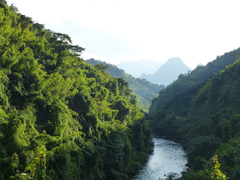
Mountainous landscape in Laos. Photo by Erdmann-Crew (Pixabay) taken on January 16, 2016. Licensed under CC0 1.0.
Natural Resources in Laos and the Sustainable Development Goals
The sustainable use of natural resources has been referred to as “advancing human well-being without undermining ecological integrity”.10 In Laos, natural resources are valued for their direct contribution to the national GDP through export-driven growth in the agricultural, forestry, mining, and hydropower industries. They are also valued by the predominantly rural, highly diverse population of Laos, who use these resources to support their livelihoods. Natural resources also provide a broad range indirect ecosystem services that benefit Laos and other downstream countries.
Geography strongly shapes natural resource-based livelihoods in Laos, with a stark contrast between people who live in mountainous areas, predominantly in the north, or areas affected by unexploded ordnances (UXOs) along the Vietnam border; and the fertile irrigated plains in the central and southern regions of Laos. Addressing these challenges is important for achieving the UN Sustainable Development Goals. Eradicating poverty and eliminating hunger in this context will only be achieved through people-centered rural development strategies that reduce gender-based inequality — and all inequality — in the distribution of natural resources and the associated risks with using them.
Decoupling the degradation of these resources from industrialization to enable inclusive and sustainable economic growth, as well as meeting the energy needs of increasingly urbanized settlements, is essential for Laos’ natural resources to be used more efficiently with less waste. This is dependent on developing the capacity of local institutions to be more inclusive and also on adequately financing them through co-operative partnerships.
Ecosystem values
In 2011, 77% of households were reported to be engaged in agricultural production activities11 and, as such, were dependent on natural resources for their livelihoods. The ecosystem services provided by natural resources in the Lao PDR provide significant value to agrarian livelihoods. There are 5.9 million ha of cultivable land in Laos, including 800,000 ha used for the production of rice and other crops in shifting cultivation systems in upland areas.12
Beyond this, the total surface area of water resources used for capture fisheries is estimated at more than 1.2 million ha, providing almost 168,000 tons per year of fish meat for consumption. This corresponds to 24.5 kg of protein consumed per capita per year, with an estimated value of 150 million USD.13 Furthermore, economic valuations in the Lao PDR have frequently highlighted the indirect values of natural resources. For example the value of flood mitigation, water resource protection, and biodiversity conservation of the Boung Kiat Ngong wetlands has been shown to be more significant than the market value of the local fisheries in the area.14 Similar results have been previously shown for the ecotourism values of forests compared with the value of rubber plantations.15
Natural Resources in Laos. Map created by ODM, view more datasets on Map Explorer.
Environmental pressures
The Lao environment is changing rapidly as a result of economic development. While many environmental impacts can be observed, the most significant pressures are associated with deforestation, soil and water pollution, altered hydrological flows and the loss of biodiversity. In addition, global climate change has continuously affected the livelihood and development of the country.
Deforestation
In 2010, Laos was reported to have 9.55 million hectares of forest cover, or 40% of the total land area. This is a significant decrease from forest coverage in the 1940s, which was then 17 million hectares or almost 72% of the total land area.16
Forest Monitoring for Action (FORMA) data, where the alert are triggered when satellites detect a significant change in forest cover compared to the previous month, suggests that forest cover loss is still a significant issue in Laos. Only 6% of the country’s primary forests remain and 93% of forests in Laos are in various stages of natural regeneration after being degraded.17
Deforestation, or a reduction in forest cover, is caused by many factors; however, the primary drivers are illegal logging; agricultural expansion, including large-scale plantations; hydropower and irrigation dams; mining, forest fires; and roads.18 The following data visualization suggests that FORMA alerts have been increasing gradually over the past decade, which suggests a decline in the quality and ecosystem function of forested areas in the Lao PDR.19
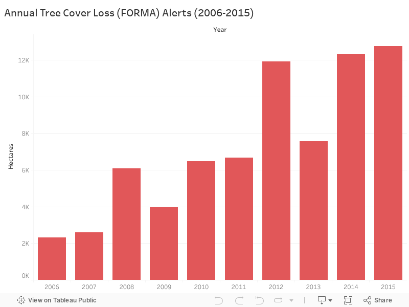
Chart created by ODM, February, 2018. Source: CAIT Climate Data Explorer 20
Pollution
Rapid changes to land management practices and natural resource use in Laos has led to the increased use of agricultural chemicals to facilitate the expansion of agricultural land, tree plantations, and mineral extraction. For example, the rapid development of large-scale industrial rubber and pulpwood plantations, with low labor inputs, has been facilitated through the use of substantial amounts of fertilizers and herbicides. These agricultural chemicals caused health problems for workers and concerns about sourcing drinking water from polluted sources, such as streams.21
Discharges from mining operations are also linked with soil and water pollution. For example, the use of cyanide in gold mining has resulted in fish kills and soil contamination.22 While larger-scale mining operations apply advanced technologies to use industrial chemicals more safely and efficiently, they have also have degraded large amounts of dense forest area.23 Artisanal mining has had environmental impacts by restricting the productive use of land and fisheries due to dredging or mercury contamination.24 Other medium-scale projects, subcontracted by Lao companies to small Vietnamese and Chinese operators, have both polluted rivers with heavy metals and impacted the hydrology of small rivers.25
On the other hand, the expansion of urban and consumer lifestyles has resulted in the rise of waste generation in the country. On average, generation of municipal solid waste is 0.70 kg per capita per day, higher than in Indonesia and the Philippines.26 Landfills are the main method for solid waste disposal, while open burning is also practiced. There are one main landfill in Vientiane capital, and four secondary landfills in Luang Prabang, Thakhek, Savannakhet, and Pakse. There are also small landfill sites in provincial towns. Of 141 District towns, only 14 are controlled landfills.27 Community dumps are poorly managed; some garbage has been disposed by burning or tossing in vacant spaces, drainage channels, and rivers. Hazardous waste like batteries, paint cans, and aerosols are also mixed with general solid waste, but there is no proper measure to keep track of potential leachate into soil, surface and underground water. With limited budget and an insufficient legal framework, institutional responsibilities and administration, waste management becomes the responsibility of households and communities, which rely on public education campaigns for information.28
Altered hydrological flows
Despite an abundance of water resources in Laos, rapid economic development, resource extraction projects, and climate change have affected hydrological flows and water security. The impacts of hydropower dams inundating upstream areas and changing flow paths, turbidity, and sediment loads in downstream areas are most significant.29 For example, river levels in areas of Laos downstream of the Nam Theun 2 Dam are dependent on the level of electricity demand in Thailand, and the amount of water released by the dam.30
Other infrastructure, such as power plants, also place demands on hydrological flows. For example, the Hongsa lignite-fired power plant plans to dam three local streams to build reservoirs for the supply of cooling water for electricity generation.31 Human induced climate change also impacts hydrological flows, resulting in more frequent extreme flooding and droughts.32
Loss of biodiversity
Laos is one of the most biodiverse countries in Southeast Asia. Surveys have identified 247 animal species including rare species like the Saola (Pseudoryx nghetinhensis), and the Giant Muntjac (Megamuntiacus vuquangensis).33 More than 481 species of fish have been identified in Laos, including 22 exotic species.34 However, it has been recognized that the country’s biodiversity has been negatively impacted by deforestation. Biodiversity has also been impacted by the trade of economically valuable wildlife from Lao forests to Vietnamese and Chinese markets, as well as the illegal transit of wildlife from South Africa through Laos to Vietnam and China.35 Other drivers of biodiversity loss include destructive logging techniques and the construction of roads that facilitate increased access to forested areas by wildlife hunters.36
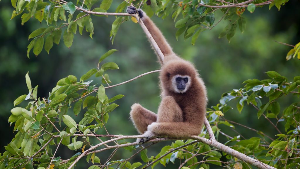
Lar gibbon, Laos. Photo by JJ Harrison, Wikimedia Commons, taken on 23 November, 2012. Licensed under CC BY 3.0.
Climate change
Dependent on natural resources for farming, hydropower, mining and wood products for development, Laos is highly vulnerable to climate change. Laos has seen more severe weather events, like storms, floods, droughts and rapid frosts. From 1990-2015, Laos faced 21 extreme floods and storms, each of which had widespread impacts on crops, livestock and livelihoods of approximately half a million people. Such extreme climate changes have impacted communities, especially the poor in rural areas, threatening food and health securities; destroying infrastructure such as roads, houses and electricity supply, which are mostly not resilient to extreme conditions; and impeding the development of the country in the long run.37
Environmental policies
Since the early 1990s, the Lao government has pursued the development of a comprehensive legal framework in order to become a “rule of law” state by 2020.38 This includes preparing laws and policies to address environmental issues. The national constitution (first passed in 1991 and then revised in 2003) emphasizes the importance of the environment by assigning its protection under the responsibilities of all citizens.39 Additionally, in 1999 the Environmental Protection Law was promulgated, which is the main legal document supporting environmental protection.40 Other laws passed on environment-related issues include the Forestry Law (2007), Wildlife and Aquatic Law (2007), Land Law (2003), Law on Agriculture (1998), and the Law on Water and Water Resources (2017).
One important focus of Lao government policy has been the development of National Protected Areas (NPAs). Originally established in 1993 as National Biodiversity Conservation Areas, NPAs were intended to protect forests, wildlife, and water; maintain natural abundance and environmental stability; and protect natural beauty for leisure and research.41 Currently, there are 23 NPAs covering 30,000 km2, or 14% of the country’s total land area.42
Other policies have been developed to reduce deforestation as the government aims to reforest the country to 70% of land area by 2020.43 In 2016, Prime Minister Order No. 15 on “Strengthening Strictness of Timber Harvest Management and Inspection, Timber Transport and Business” was issued to strictly regulate wood processing businesses and logging, including prohibiting exports of unfinished wooden products.44 In 2015, the Lao government entered negotiations with the European Union (EU) to negotiate a Voluntary Partnership Agreement as part of the Forest Law Enforcement, Governance and Trade program. This program aims to establish a system by which only certified legally harvested and processed timber can be exported to EU countries.45
In response to climate change, the Government of Lao PDR ratified the UNFCCC in 1995, the Kyoto Protocol in 2003 and the Paris Agreement on Climate Change in 2016. The government created the National Strategy on Climate Change in 201046 and also highlighted the importance of natural resources and environment in Outcome 3 of the 8th National Socio-Economic Development Plan (NSEDP) (2016-2020)47. The 8th NSEDP outlined a green growth strategy for sustainability of natural resources and environment, and for resilience to natural disasters and climate change. Linked with the implementation of the 8th NSEDP, in 2017, the government adopted a green growth initiative, part of the World Bank’s Country Partnership Framework for Lao PDR (2017-2021)48, to pave the way for sustainable development, environmental protection and climate resilience in the country.
Related to Environment and Natural Resources
Last updated: September 2018
References
- 1. Ministry of Natural Resources and Environment. 2012. “Lao Environment Outlook 2012.” Accessed July 2017.
- 2. Phommakaysone K. 2016. “The Geology and Mineral Resources of Lao PDR.” Accessed 11 June 2018.
- 3. Bank of the Lao PDR. 2017. “Lao PDR: Annual Economic Report 2017.” Accessed 14 September 2018.
- 4. Department of Forestry. 2018. “Lao PDR’s Forest Reference Emission Level and Forest Reference Level for REDD+ Results Payment under the UNFCCC.” Accessed 12 June 2018.
- 5. World Bank. 2018. “Data: Lao PDR.” Accessed 12 June 2018.
- 6. RECOFTC-The Center for People and Forests. 2014. “Community Forestry Adaptation Roadmap to 2020 for Lao PDR.” Accessed 12 June 2018.
- 7. Ministry of Natural Resources and Environment. 2012. “Lao Environment Outlook 2012.” Accessed July 2017.
- 8. WEPA. 2012. “State of Water: Laos.” Accessed 13 June 2018.
- 9. IUCN. 2011. “Wetland Priority Sites in Lao PDR: The Top Five Priority Sites.” Accessed July 2017.
- 10. Mansfield, S. 2009. “Sustainability.” In N. Castree, D. Demeritt, D. Liverman, and B. Rhoads (eds.) A Companion to Environmental Geography, 37-49. Oxford, UK: Wiley-Blackwell. Accessed Jul 2017.
- 11. Ministry of Agriculture and Forestry. 2012. “Lao Census of Agriculture 2010/11: Highlights.” Accessed July 2017.
- 12. Ministry of Natural Resources and Environment. 2012. “Lao Environment Outlook 2012.” Accessed July 2017.
- 13. Mekong River Commission. 2013. “An Introduction to the Fisheries of the Lao PDR.” Accessed December 2017.
- 14. Kyophilavong, P. 2011. “Economic evaluation of wetland ecosystems in Lao PDR – Case Study: Boung Kiat Ngong (BKN), Champasak Province.” Accessed February 2018.
- 15. Schipani. S. 2007. “Ecotourism as an Alternative to Upland Rubber Cultivation in the Nam Ha National Protected Area, Luang Namtha.” Accessed February 2018.
- 16. Department of Forest Resource Management, Ministry of Natural Resources and Environment. 2016. “Fifth National Report to the United Nations Convention on Biological Diversity.” Accessed December 2017
- 17. FAO. 2015. “Global Forest Resource Assessment 2015.” Accessed February 2018.
- 18. USAID – LEAF. 2015. “Drivers of Forest Changes in the Greater Mekong Subregion – Lao PDR.” Accessed December 2017.
- 19. Global Forest Watch. 2013. “Tree Cover Loss (FORMA) Alerts – Humid Tropics.” Accessed February 2018.
- 20. Ibid. Accessed February 2018.
- 21. Molina, R. 2011. “Camps, Children, Chemicals, Contractors & Credit: Field Observations of Labour Practices in Plantations & Other Social Developments in Savannakhet and Champasak.” Accessed December 2017.
- 22. Poverty – Environment Initiative. 2010. “Economic, Social and Environmental Impacts of Investments in Mining: Lao PDR Issues Brief.” Accessed December 2017.
- 23. Delang, C., Toro, M., & Charlet-Phommachanh, M. 2013. “Coffee, mines and dams: conflicts over land in the Bolaven Plateau, southern Lao PDR.” The Geographical Journal, 179(2): 150-164. Accessed December 2017.
- 24. Barney, K. 2017. “Re-assembling Informal Gold Mining for Development and Sustainability? Opportunities and Limits to Formalisation in India, Indonesia and Laos.” In K. Lahiri-Dutt (ed.) Between the Plough and the Pick: Informal Mining in the Contemporary, ANU: Australian National University Press. Forthcoming. Accessed December 2017
- 25. Land Issues Working Group. 2012. “Mining in Nonghet, Chameun Village.” Accessed December 2017
- 26. United Nations in Lao PDR. 2015. “Country Analysis Report: Lao PDR.” Accessed 12 September 2018.
- 27. The Asia Foundation. 2017. “Love Laos, Keep it Clean.” Accessed 12 September 2018.
- 28. Phonekeo I. and Inthavong P. 2010. “Solid Waste Management in Laos.” Accessed 12 September 2018.
- 29. Matthews, N. 2012. “Water Grabbing in the Mekong Basin: An Analysis of the Winners and Losers of Thailand’s Hydropower Development in Lao PDR.” Water Alternatives, 5(2): 392-411. Accessed December 2017.
- 30. Baird, I.G. & Quastel, N. 2015. “Rescaling and Reordering Nature-Society Relations: The Nam Theun 2 Hydropower Dam and Laos-Thailand Electricity Networks.” Annals of the American Association of Geographers, 105(6): 1221-1239. Accessed December 2017.
- 31. Land Issues Working Group. 2010. “The Potential Impacts of Lignite Mining on the Environment and Local Livelihoods in Hongsa District, Sayabouli Province, Lao PDR.” Accessed July 2017.
- 32. IUCN. 2012. “Climate Change and Its Impact on the Lao and Cambodian People.” Accessed July 2017.
- 33. Department of Forest Resource Management, Ministry of Natural Resources and Environment. 2016. “Fifth National Report to the United Nations Convention on Biological Diversity.” Accessed December 2017
- 34. Mekong River Commission. 2013. “An Introduction to the Fisheries of the Lao PDR.” Accessed December 2017.
- 35. The Guardian. 2016. “Revealed: How Senior Lao Officials Cut Deals With Animal Traffickers”. Accessed July 2017.
- 36. Ministry of Natural Resources and Environment. 2012. “Lao Environment Outlook 2012.” Accessed July 2017.
- 37. World Health Organization & United Nations. 2015. “Lao PDR: Climate and Health Country Profile – 2015.” Accessed 8 June 2018.
- 38. Ministry of Justice. 2009. “Master Plan on Development of Rule of Law in the Lao PDR Toward the Year 2020.” Accessed December 2017.
- 39. National Assembly of the Lao PDR. 2003. “Lao People’s Democratic Republic’s Constitution of 1991 with Amendments through 2003.” Accessed December 2017.
- 40. National Assembly of the Lao PDR. 1999. “Environmental Protection Law (1999).” Accessed December 2017.
- 41. Lao-Swedish Forestry Programme. 2001. “Review of the National Protected Area System of Lao PDR.” Accessed December 2017.
- 42. World Bank. 2014. “Environmental and Social Management Framework: Protected Area And Wildlife Project.” Accessed December 2017.
- 43. Forest Trends Policy Brief. 2014. “Forest Conversion in Lao PDR: Implications and Impacts of Expanding Land Investments.” Accessed May 2017.
- 44. Lao EU-FLEGT. 2016. “FLEGT Process Enforces PM Order No.15 to Improve Forest Governance and Fight Deforestation to Ensure Legal Timber Trade Agreement With EU.” Press Release. Accessed December 2017.
- 45. EU-FLEGT Facility. 2017. “Q&A: Laos-EU Voluntary Partnership Agreement.” Accessed July 2017.
- 46. Government of Lao PDR. 2010. “National Strategy on Climate Change of Lao PDR.” Accessed 8 June 2016.
- 47. Ministry of Planning and Investment. 2018. “8th Five-Year National Socioeconomic Development Plan (2016–2020).” Accessed 8 June 2018.
- 48. World Bank. 2017. “Country Partnership Framework for the Lao People’s Democratic Republic, 2017-2021.” Washington, D.C. : World Bank Group. Accessed 8 June 2018.

